test

Into the depths

CONSERVATION SCIENTISTS HAVE UNLOCKED THE MYSTERIES OF HOW SHARK AND RAY SPECIES MOVE UP AND DOWN THE OCEAN WATER COLUMN, IN EFFORTS TO BETTER UNDERSTAND THEM AND SECURE THEIR FUTURE.

While we start to understand some of the migration patterns of certain shark species and have begun to pinpoint some of their meeting spots, the mysterious lives of sharks and rays in the deeper ocean columns has not been extensively studied – until now. From some of the most mysterious deep-diving species, to those that spend more time in shallower water, a new study, led by ZSL’s Institute of Zoology and Hopkins Marine Station at Stanford University, is the first ever global analysis of shark diving behaviour. A collaborative research team shows how the elasmobranch community which includes sharks, skates and rays use the vertical dimension of the ocean.

Using data from 989 biotelemetry tags – tags which allow remote measurements of behavioural activity – the global team of 171 researchers from 135 institutions analysed 38 species of elasmobranchs from the North Pacific to the Indian Ocean, and the Arctic to the Caribbean. The researchers hope that this new information on shark diving behaviour will help improve the knowledge about sharks’ ecological roles and foster conservation management plans that were previously hindered by lack of data for certain species.

Thirteen species were found to dive to depths greater than one kilometre beneath the surface. Whale sharks were found to dive to a staggering 1,896m while great white sharks were recorded diving deeper than 1,200m, providing new and important insights into the behaviour of these ocean giants.

“Knowing just how deep some species dive (or don’t dive), will help us to inform much needed conservation plans for these species and their relatives   – for example, more widespread use of bycatch avoidance strategies. It will also help us understand how these animals are likely to respond to the predicted climate induced changes to our oceans,” explains Dr David Curnick, research fellow at the ZSL Institute of Zoology and co-lead author of the paper.

WHALE SHARKS WERE FOUND TO DIVE TO A STAGGERING 1,896M WHILE GREAT WHITE SHARKS WERE RECORDED DIVING DEEPER THAN 1,200M

The data on shark diving behaviour also revealed how some species vary their depth in different parts of the world. It showed how this changes between night and daytime periods as the predators move up and down in the water to hunt their prey and, in some cases, avoid being hunted themselves. Although the reasons why species usually known to frequent shallower waters were recorded diving into deep, dark waters is not confirmed, the study suggests it is likely a combination of seeking food sources, body temperature regulation, reproduction, and predator avoidance.

The team found that although many species can and will undertake deep dives, 26 of 38 species including the oceanic whitetip shark, tiger shark, scalloped hammerhead, and silky shark spent more than 95% of their time in the top 250m of the water column, depths where they are most likely to interact with fishing gears.

INVESTIGATING HOW ELASMOBRANCHS USE THE VERTICAL DIMENSIONS OF THEIR HABITAT IS KEY IN UNDERSTANDING THE WAY THEY LIVE.

Dr Curnick says: “The way that large marine animals use the horizontal space in our ocean has been well studied. However, until now, comparative studies in the vertical planes have been limited, despite the ocean being an average 3.5km deep and elasmobranchs occupying all levels within this dynamic environment.

“Investigating how elasmobranchs use the vertical dimensions of their habitat is key in understanding the way they live, but also how anthropogenic stressors are impacting them. This helps us to find ways to better protect them through more informed monitoring strategies for example. By looking at a wide range of elasmobranch species in this study, we demonstrate how they face overlapping risks, such as targeted fisheries and getting caught in nets, also known as ‘bycatch’.”

More than one third of all sharks and rays are threatened with extinction, according to the IUCN Red List of Threatened Species. Having a three-dimensional map of how elasmobranchs use the ocean is vital in understanding the roles they play in wider ecosystems and to determine their individual exposure to threats.

“This massive dataset provides new insights into the vertical movement patterns of sharks and rays on a global scale for the first time. This is an important step for both understanding which sharks and rays are most likely to face threats, but also to consider how changing temperature and oxygen levels may influence their vertical distributions,” comments Stanford Postdoctoral Research Fellow and co-lead author of the paper, Dr Samantha Andrzejaczek.

MORE THAN ONE THIRD OF ALL SHARKS AND RAYS ARE THREATENED WITH EXTINCTION.

As the world warms due to climate change, it is predicted that the structure of the ocean is also going to change. With many areas suffering oxygen depletion and shifts in ocean chemistry, many species have already been driven into unfamiliar territory and habitats. However, a better understanding of their fundamental ecology can inform predictions on how reduced oxygen availability at certain depths could limit shark, ray and skate vertical movements and help to predict the wider implications of climate change.

“I’ve seen for myself the terrible threats that shark populations face around the world and how they have been decimated in recent decades.  I hope that this incredible research will help scientists, conservationists and fisheries managers better protect these astonishing – and hugely important – species in the future so that they can retain their rightful place in the ocean,” concludes Ernesto Bertarelli of the Bertarelli Foundation.

Read article on Oceanographic Magazine
Written by NANE STEINHOFF
Photographs by BYRYAN DALY

Additional photographs by Alex Kydd, Guy Stevens (Manta Trust), Mark Royer, and Uli Kunz.

5 Innovative Technologies Saving Our Oceans

Solutions for the seas.

In 2021, the Earth’s oceans reached their hottest, most acidic, and highest sea levels on record. Luckily, many companies and organizations are creating innovative technologies to save our oceans.

Planetary Technologies’ Ocean-Based Carbon Removal

Planetary Technologies is the first climate technology to remove carbon from the atmosphere by using direct ocean capture. Planetary’s proprietary technology safely purifies mine waste into a mild, nontoxic antacid that is released into the ocean. This antacid rapidly enhances and speeds up the ocean’s natural ability to draw out and permanently sequester carbon from the atmosphere. The additional alkalinity in the ocean also restores damage caused by increased acidification. 

Planetary Technologies' ocean-based carbon removal technology to save our oceans
Photo Credit: Planetary Technologies

Additionally, the purification of mining rock produces clean, green hydrogen as a byproduct, which can be used as a zero-carbon fuel source to reduce the consumption of fossil fuels. If all of this wasn’t enough, Planetary’s three-pronged process also involves extracting metals from mining waste, which can be used in batteries. This is essential in promoting an electric-powered future.

In 2022, the company was awarded $1 million from Elon Musk’s XPRIZE Carbon Removal Milestone Award, which it plans on using to achieve a full-scale demonstration of its technology. As Planetary’s CEO Mike Kelland said

“The global community agrees that we need a three-pronged approach to stop the harmful effects of climate change – adapt, reduce emissions and remove carbon – and Planetary’s process does all three, the most critical being our ability to remove carbon dioxide form the air”

Clearbot’s Trash Clean Up and Data Collection

An estimated 11 million pounds of waste are put into our oceans each year. Clearbot is attempting to lower this number with its Clearbot boats. These electric-powered, AI-enabled, and autonomous boats tackle the challenges of plastics, flood debris, and biomass in waterways. 

For example, the three-meter-long Clearbot Neo autonomously collects floating garbage by systematically moving up and down designated sections of water. It skims the surface to scoop up floating trash onto its onboard conveyor belt and uses AI to recognize and log the types of trash collected. The trash is then properly disposed of based on its category. With 4 hours of battery life, Clearbot Neo allows a one-man team to deploy and capture hazardous and pollutant waste of up to 1-ton per day.   See video on https://youtu.be/u2bApYIbCmw

Using its two-camera detection system, Neo also collects valuable data. One camera surveys the water’s surface to avoid marine life, navigational hazards, and other vessels. The second camera photographs each piece of trash that lands on the conveyor belt and transmits its image and location to the company’s data compliance system, hosted by Microsoft’s Azure platform. When the data from these two cameras are merged with other information like sea current and tide, the trash’s source and the water’s quality are more easily identifiable. 

Saildrone’s Autonomous Vessels

Saildrone’s fleet of autonomous wind and solar-powered vessels collect real-time, high-quality data throughout the ocean. This data can be used to inform sustainable fisheries management, detect oil spills, conserve threatened species, map the seafloor, and help scientists understand how the climate is changing ocean ecosystems like coral reefs. 

The company’s wing technology enables a mission duration of up to 12 months; its wind propulsion system allows the vehicles to travel at an average speed between two to six knots under wind power. To date, Saildrone’s vehicles have sailed over 800,000 miles with over 18,000 days at sea with little to no carbon footprint.

Saildrone's Saildrone Surveyor innovative technology saving the oceans
Photo Credit: Saildrone

One of Saildrone’s vessels is the Saildrone Surveyor, which autonomously set sail in July 2021 from San Francisco to Honolulu. The Saildrone Surveyor was created for ocean mapping; its sensors look at underwater ecosystems and map the seafloor to a depth of 23,000 feet. Saildrone intends to map the entirety of Earth’s oceans in 10 years—80 percent of which is currently unmapped. Mapping the Earth’s oceans will help scientists understand climate change processes, the path and strength of tsunamis, and more. 

SafetyNet Technologies’ Selective Fishing Light

Over 9 million tonnes of bycatch are caught globally every year, negatively impacting fishermen, the marine ecosystem, marine biodiversity, and fish stock. In an attempt to lower this number, SafetyNet Technologies created Pisces, a kit of 10 LED lights that fit fishing gear to allow more precise fishing. As a result, users can adapt to regulations, avoid fines, and fish more sustainably.  See video on https://youtu.be/mcbNv_OhFkA

Pisces can be adapted in numerous ways depending on what color, intensity, and flash rate are used, allowing Pisces to work in multiple different fisheries. Its LED lights also significantly reduce bycatch by attracting some species of fish and scaring others away. As a result, Pisces can be adjusted to help catch more of your target species while reducing bycatch. 

SafetyNet Technologies also created CatchCam, a robust underwater camera that allows users to see their gear in action under the ocean. This gives users insights into how fish behave in nets and if their bycatch mitigation methods, like square mesh panels, are working.

RanMarine’s WasteShark

Created by RanMarine Technology, a robotic autonomy technology company, WasteShark is a small robotic device that removes floating waste, plastics, and harmful algae from the surface of the water. This autonomous surface vessel is emission-free and reduces the effects of plastic pollution on the Earth’s oceans. As WasteShark’s founder, Richard Hardiman told Tomorrow’s World Today,  

“Our purpose is to develop technology to make our world a more livable place and ease the pressure humans are adding to our fragile water resources and ecosystems.” 

The robot has 180 liters (47.5 gallons) of capacity, an 8-hour runtime, and can remove 1100 pounds of waste a day. Ran Marine’s DataShark can also collect live data to measure accurate water health quality. This vessel can monitor temperature, depth, dissolved oxygen, turbidity, blue-green algae, crude, refined oils, and more to identify potential contaminants early to minimize their impact on the environment. 

Photo Credit: RanMarine, WasteShark

At the Consumer Electronics Show in 2022, RanMarine also introduced the SharkPod, which is the world’s first autonomous floating docking station for waste-clearing drones. This tool will be able to deploy, dock, and charge up to five WasteShark drones at one time, allowing for a twenty-four-hour autonomous solution to remove waste from the water. Together with WasteSharks, the SharkPod would be able to remove up to 100 tons of debris and waste per month. 

For more information on the world’s oceans, check out how Earth’s oceans have reached record acidity, temperature, and sea levels, Tomorrow’s World Today’s interview with a National Geographic artist about ocean conservation, NFT’s helping coral reefs, and coral reefs around the world

To read the article by Tomorrows World Today see this link

Sailing drones to clean plastic in the Lauwersoog port

From now on, five sailing drones will be used to fish plastic waste from the port of Lauwersoog. Initiators GPBO and Ran Marine have received a subsidy of almost one million for the Wadden Fund project.

Drones have to clean up plastic in Lauwerseach harbor:

The plastic waste that is collected is given a new destination. With a mobile installation, the material must be processed into, among other things, paving blocks and roof and sidewalk tiles.

In total, the project will cost almost one and a half million euros and it does not stop at the collection of floating waste. It is also the intention that companies in the port hand in their waste plastic before it can end up in the water.

Salinization of agricultural land tackled

In total, 3720 tons of plastic must be processed sustainably every year. In the future, these types of installations can go to other ports for the same purpose. Because the plastic is reused and incinerated, it also reduces CO2 emissions.

In total, the Wadden Fund announced an investment of four million euros on Wednesday. This also involved a plastic and textile recycling project in the Eemshaven and a project to tackle the consequences of salinization of agricultural land.
See full article and video by Omrop Fryslân on link

Rare coral reef discovered near Tahiti

A scientific research mission supported by UNESCO has discovered one of the largest coral reefs in the world off the coast of Tahiti. The pristine condition of, and extensive area covered by, the rose-shaped corals make this a highly valuable discovery.

” To date, we know the surface of the moon better than the deep ocean. Only 20% of the entire seabed has been mapped. This remarkable discovery in Tahiti demonstrates the incredible work of scientists who, with the support of UNESCO, further the extent of our knowledge about what lies beneath. ” Audrey Azoulay, UNESCO Director-General

Highly unusual discovery

The reef is located at depths of between 30 and 65 metres. It is approximately 3km in length and between 30m and 60/65m wide, which makes it one of the most extensive healthy coral reefs on record. The giant rose-shaped corals are up to 2 metres in diameter.

This is highly unusual because, up to now, the vast majority of the world’s known coral reefs sit at depths of up to 25m. So this discovery suggests that there are many more large reefs out there, at depths of more than 30 metres, in what is known as the ocean’s ‘twilight zone’, which we simply do not know about.

” It was magical to witness giant, beautiful rose corals which stretch for as far as the eye can see. It was like a work of art.” Alexis Rosenfeld, French photographer and founder of the 1 Ocean campaign


A step forward for science

This expedition is part of UNESCO’s global approach to mapping the ocean. Coral reefs are an important food source for other organisms so locating them can aid research around biodiversity. The organisms that live on reefs can be important for medicinal research and reefs can also provide protection from coastal erosion and even tsunamis.

“French Polynesia suffered a significant bleaching event back in 2019 however this reef does not appear to have been significantly affected. The discovery of this reef in such a pristine condition is good news and can inspire future conservation. We think that deeper reefs may be better protected from global warming.” Dr. Laetitia Hedouin, France’s National Centre of Scientific Research (CNRS)

Read full article by Ocean Decade on this link 

Could algae be the sustainable food of the future?

Is now the time to get on board with eating the vegetables of the ocean, asks Lauren Taylor

Figuring out how we can eat more sustainably is going to be an ongoing issue as the world becomes more populated and the climate crisis intensifies. And, from munching on protein-packed insects to lab-grown meat, greener (and animal welfare-conscious) alternatives are being explored – the latest being algae.

It should be no surprise, really, that as we’ve well and truly exploited what’s on land, we were destined to delve further into the sea. But with environmentalists warning of the devastating impacts of overfishing, one expert suggests we need to eat the food from the bottom of the ocean, rather than the top.

Patricia Harvey, professor of biochemistry and head of bioenergy research at the University of Greenwich, says: “We’ve learned on land to eat the vegetables, we haven’t yet learned with regards to the ocean how to eat the vegetables – the algae.”

<p>Algae contains pro vitamin A and omega 3 polyunsaturated fatty acid</p>

What is ‘ocean flexitarianism’?

It’s a new concept which asks that – like “flexitarianism” or “casual vegetarianism” where people eat a mostly plant-based diet with some meat occasionally – we eat more vegetables from the ocean than fish.

Algae is the umbrella term for a huge, diverse group of aquatic organisms, found in both fresh and seawater, that conduct photosynthesis to generate oxygen. One form of algae most people are familiar with is seaweeds, such as nori and kelp, and Japanese diets in particular include several types. But Harvey believes the untapped potential in sustainable food sources in the ocean is huge.

Why is eating algae sustainable?

“We know we’ve got to feed a lot more people by 2050, the population is growing, and we also know that if we keep on putting intensive agriculture on the land, we’re going to completely screw up the biodiversity,” says Harvey. But we can’t simply turn to the ocean as we are, because we typically eat carnivorous fish like tuna and cod.

“About 70 per cent of the Earth is covered in water and about 97 per cent of that water is ocean. If we just dive into the ocean to feed all those people, if we then turn to the ocean to [only] eat the carnivores, we’ll then mess up the ocean. That’s why it’s incredibly important to get more people to grips with eating algae, the vegetables, at the bottom of the ocean. So we can get a sustainable exploitation of the ocean to feed more people.”

Read full article Independent.co.uk

Smart Cities’ Challenge: Bridging Data, In Real Time

“Smart cities” are a technology-driven approach to many previously irretractable urban problems, from alleviating congestion to improving pedestrian safety to enhancing water quality. While tier-1 cities such as San Francisco and Denver may come to mind as leaders in smart city technology deployment, look no further than Chattanooga, Tennessee. This picturesque city, nestled in the foothills of the Appalachian Mountains, is an example of a smart city employing cutting-edge approaches to improve residents’ lives and mobility.

Kevin Comstock, smart city director for the City of Chattanooga, recently shared his experiences and insights on making the shift to smart in a panel joined by Richard Hardiman, CEO and founder of RanMarine, and William Muller, vice president of business development for Seoul Robotics. I had the opportunity to moderate the discussion.

Panelists are optimistic about the inroads smart cities will be making in transportation and civic life over the coming decade. Comstock sees smart cities paving the way for improved health, energy and mobility, “key areas smart cities can focus on and make tangible improvements over the next five to ten years.”

Data is the key, and is now available from a range of sources across cities. Muller says the key to smart city growth will be bringing this data together from different technologies and systems, “and making it useful as a whole big picture.” “Open” is the operative word, he adds. “Data is going to need to be accessible to many different parties, from connected vehicles, to transportation systems, to a person down the street looking at his cell phone.”

Chattanooga has been taking these steps, implementing a centralized hub that monitors real-time information on the health of its transportation network, as well as cameras that detect vehicles — both cars and bicycles — for better operation of traffic signals. The city has also been tying its databases together from sources across both the city and county to compile information about delays, congestion, construction, where parking or transit options are most available, and providing that information to the public in an open architecture format.
Comstock’s team has also been working with academia on a US Department of Transportation connected vehicle program test bed project which provides Chattanooga with one of the first connected vehicle projects in the country. The project is intended to provide connection between freight, transit and emergency vehicles, as well as monitor pollution and self-adjusting signals to compensate for increases in the pollution and other factors. “At the end of the day, businesses want to get their goods or deliver their goods,” says Comstock. “The more robust and smart the system, the more reliable sustainable system or delivery platform, the better off they’re going to be. The economic development piece of that becomes more in play at that point in time.”

Connected vehicles have caught the attention of many smart city planners, but the proliferation if autonomous vehicles is still some time away. “I don’t believe we’re in autonomous vehicles state yet, but we’ll definitely be there over the coming decade,” says Comstock. “We have to have connectivity before we have autonomy. The first generation of autonomous vehicles “are going to deliver pizza, groceries and packages before they ever deliver people,” Comstock cautions. “Until those platforms are discovered and vetted out, a certain safety protocol has been addressed.”

Autonomous vehicles currently have found their place in “very active in heavy industries, especially mining, and things like that, where the environments are more conducive to that technology,” says Muller. “The same technology developed for those industries, specifically the 3D data, 3D LIDAR sensors and 3D radars, are going to be beneficial for smart cities.”

Expect to see increased automation as well across the board, Hardiman says — a point demonstrated by the Covid crisis. “When we have a complete shutdown of the cities because of a pandemic, with the loss of taxes, we realize we need to rely on nonhuman functionality in many ways. Robotics is a potential cure-all to the next pandemic or the next event. We can survive better as a city, as a community, using robotics.”

The key to these efforts is data, and the ability to move it quickly to where it’s needed. “We have an organization within the city government that’s called the Office of Operational Management and Open Data,” Comstock explains. “We look at the resources that we have, the different data sets, different databases, and pull information into a centralized location.” One aspect is development of a LIDAR-based data system “to look at pedestrian safety as a key component of utilizing technology and help solve the problem.”

Another initiative Chattanooga is undertaking is “looking at a predictive crash model — taking and aggregating data from across the city in conjunction with the police department and others, to pull together a roadmap and this general understanding of what our pain points are, and how we can help mitigate some of those things before they become a problem. It’s about proactive thinking about these things, applying them in new ways.”

Even for the smallest-scale project, such as making an intersection or crossing smart, is the large number of components involved,” says Muller. “A lot of different technologies are needed to solve singular problems within a particular intersection.”

Along with open data, another challenge for smart cities is achieving interoperability between cities and government agencies at all levels, Comstock points out. “We recognize that the interoperability between a city like Chattanooga and state departments of transportation or the other agencies that surround us, like Atlanta or Nashville, that implementations performed here need to work in other locations, and people that come in from those locations need to work here,” says Comstock. “There needs to be an Internet of Things approach to how we look at technologies. For example, right now you can use a cell phone. It doesn’t matter who the manufacturer is, or who your carrier is. You can call anyone in the world at any point in time. The agnostic features of that need to be replicated in a smart cities environment.”

Read article on Forbes

Why water quality matters

What is the first thing that comes to mind when you hear the words Water Quality? We bet you think of your drinking water and whether or not it’s actually safe to drink. You might even think of a water filtration system that cleans your drinking water.

But water quality refers to more than just your drinking water.

Take rivers, for example. Testing the water quality in rivers allows us to know the biological factors that could be impacting aquatic life and ecosystems.

Why we must monitor our waters

Things like algae and phytoplankton have a huge influence on rivers since they can affect groundwater. Monitoring the rivers can help researchers predict, learn and determine the human impacts on these sensitive ecosystems. Measuring the water quality in these bodies of water can also determine if restoration projects need to be undertaken or simply to determine if the water quality meets environmental standards.
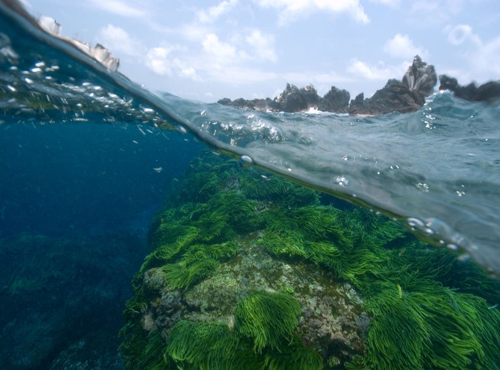
Algae and plankton

Algae are plant-like organisms found in rivers, lakes, ponds and oceans. And even in snow. They come in a variety of structures, from simple plankton to large seaweeds. Single-cell phytoplankton float on the water but can, at times, grow in colonies large enough to be seen. While they have plant-like abilities, they are not actually plants.

Phytoplankton falls into two classes, namely algae and cyanobacteria. Most freshwater phytoplankton is made up of green algae and cyanobacteria, (which is also known as blue-green algae), and is actually a type of bacteria. Cyanobacteria are literally the only bacteria that contain chlorophyll. (The bluish tint that you see in blue-green algae actually comes from their pigments called phycoerythrin and phycocyanin).

Read our blog: Reducing Harmful Green-Algae Blooms Is Crucial to Protecting Aquatic Life

Seaweeds

Macroalgae (seaweeds), on the other hand, generally attach themselves to the ocean floor (except seaweeds like Sargassum that actually float on the surface of the water and do not attach to the floor bed).

Read our blog: Why we must tackle our Sargassum issue

When phytoplankton and macroalgae growth gets out of control, they can pose dangers to aquatic life. Monitoring these levels is therefore crucial to maintaining balance in the ecosystems where they live.

Dissolved oxygen

Another water quality test that is generally undertaken is dissolved oxygen levels. Dissolved oxygen basically refers to the amount of dissolved oxygen in the water that is available to aquatic life. Testing these levels is important because of its influence on the organisms living within that body of water. When these levels are too high or too low aquatic life can become affected, as can the water quality.

All forms of aquatic life depend on dissolved oxygen, including plants, fish, invertebrates and bacteria. Aquatic life that lives on the ocean floor or in deeper waters need less dissolved oxygen, while those living in shallow waters need more. It might surprise you to learn that organisms responsible for decomposing organic matter at the bottom of the ocean, such as bacteria and fungi, also use dissolved oxygen to help them do their work.

In a stable body of water with no stratification (a system or formation of layers), dissolved oxygen will remain at 100% air saturation. However, the deeper you go, the less dissolved oxygen you will find. This is primarily due to the fact that these deeper waters have not been in contact with air. The actual amount of dissolved oxygen will vary depending on things like water temperature, salinity and pressure.

But how exactly does low dissolved oxygen levels affect aquatic life?

Let’s take a closer look at salmon and trout which are cold-water fish. These fish will generally avoid waters where the dissolved oxygen levels are too low because low levels will cause them to die within a matter of days.

Furthermore, low levels of dissolved oxygen will not only delay the hatching of their eggs but will also impair their growth and lower their rate of survival. Carp, on the other hand, are slightly hardier and can survive and thrive in waters with lower dissolved oxygen levels. It goes without saying then that if dissolved oxygen levels in rivers and oceans drop too low, the fish in those regions will begin to die off.

Equally, if dissolved oxygen levels are too high, this also creates problems as supersaturated water can cause gas bubble disease in fish and invertebrates. Gas bubble disease in fish is the equivalent to “the bends” in scuba divers. Fish can easily die from gas bubble disease, and since they might not show symptoms, it makes it difficult for researchers to diagnose them.

Dead Zones

 A dead zone is an area of water where there is little to no dissolved oxygen. This usually occurs when there are too many nutrients like phosphorous and nitrogen in the water, causing blue-green algae overgrowth. Needless to say, aquatic life cannot survive in these zones which are usually found near heavy human populations. And humans are usually the cause of dead zones due to agricultural and industrial activities.

In developed countries, manure and fertilizers are the main culprits, while in developing countries untreated wastewater from sewage and industry are the culprits. Since these facilities are less regulated than in developed countries, wastewater is often dumped into rivers, lakes, creeks or the ocean.

According to National Geographic, scientists have identified 415 dead zones worldwide.

Water Quality testing has therefore become crucially important if we are to ensure that both our aquatic life and humans survive.

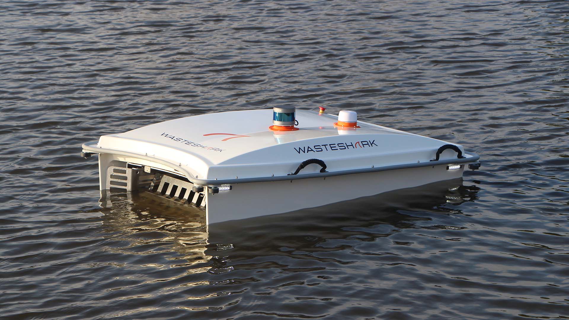
One such company that offers a combined solution to both water quality testing and clearing of pollution from bodies of water is RanMarine Technology.

Their WasteShark and DataShark collect data that is geotagged and timestamped to give an accurate picture of the water quality health within an ecosystem, thus allowing one to accurately monitor the quality of the water to help verify compliance with pollution regulations, identify potential contaminants early to minimize the impact on the environment and, basically, to make the water safe for everyone to enjoy.

It’s thanks to advances in water quality testing like these that we are able to enjoy clean drinking water and being able to swim safely in rivers and lakes

These are the Top Environmental Engineering Startups in The Netherlands (2021)

This article showcases our top picks for the best The Netherlands based Environmental Engineering startups. These startups and companies are taking a variety of approaches to innovating the Environmental Engineering industry, but are all exceptional companies well worth a follow.

We tried to pick companies across the size spectrum from cutting edge startups to established brands.

We selected these startups and companies for exceptional performance in one of these categories:

  • Innovation
    • Innovative ideas
    • Innovative route to market
    • Innovative product
  • Growth
    • Exceptional growth
    • Exceptional growth strategy
  • Management
  • Societal impact

RanMarine USA

RanMarine USA has merged US operations with the global operations of RanMarine Technology B.V., developer of the WasteShark technology and based in Rotterdam, Netherlands. The WasteShark is a data-driven, autonomous aqua-drone that cleans marine waste, while collecting critical water quality data from local water sources.

The WasteShark is a unique smart city solution which is financially feasible for communities of all sizes and delivers quantifiable results day one. Waste and Pollution Removal – efficiently and effectively removes over 1000+ pounds of marine waste and pollution per day.

Water Quality Safety – collects and analyzes real-time data about water quality to assist with compliance with pollution regulations and identify potential contaminants early to minimize impact on the aquatic ecosystem, environment, and constituents. Biomass Removal – removes biomass (e.g., hyacinths, duckweed, algae) at the surface, which helps maintain aquatic ecosystems and mitigates potential damage to water equipment and facilities.

Oil Waste Collection – designed to operate in confined areas around boats, ships, docks and slips. The WasteShark can be fitted with a special drum oil skimmer for spill collection, and high-quality crude and refined oil sensors can be added for water quality data collection and hydrocarbon detection..

Read full article by The Startup Pill

These drones look for trash in waterways

In a river in the Danish city of Århus, a small machine called the WasteShark now autonomously sails through the water collecting trash, bringing it to shore, and then recharging itself. Soon, a drone will begin flying through the air to help: Using a special lens that collects data to be crunched by a machine learning algorithm, that drone can identify pieces of plastic or other garbage and direct the sailing drone to pick them up. The system can also identify oil spills, which the WasteShark can help clean up with a special filter.

“We’re testing a technology that can be scaled in a lot of different ways,” says Martin Skjold Grøntved, a special consultant for the Danish Climate Ministry. While the small trash-eating drone isn’t new, the addition of the flying drone makes it possible to find more garbage more quickly. The sailing drone also hasn’t been used to clean up oil spills in the past, because without the drone overhead scanning the water, it wouldn’t be able to identify the oil.

he tech startup Kinetica worked with the agency to provide a data platform, running on Oracle Cloud Infrastructure, that makes the trash detection algorithm run quickly. This isn’t the first time they’ve helped equip drones to detect trash. Kinetica also worked with the nonprofit San Francisco Estuary Institute to test another project that uses drones to track how much waste is entering waterways to help understand how well waste-prevention efforts are working. In the past, that data was difficult to gather at a large scale. “Resources are limited, and city programs have only so much to put towards these efforts,” says Tony Hale, program director for environmental informatics at the San Francisco Estuary Institute. “Nonprofits have only so many people to put towards these efforts. And it’s a very time-intensive process to go out and just do the cleanups, first of all, let alone to count the amount of trash and then characterize it by certain categories. What this drone-based and machine learning-based method offers is a way to expand the geography.”

Read the full article by Fast Company – article

The Health of our Waters and Innovations to Protect Them

If we had to ask ourselves if we were doing enough to protect our waters, we’d have to admit to some pretty hard truths. Because really, all it takes is one glance around the globe to see that we need to be doing a lot more to understand, measure, and manage our waters, and we need to be doing it now.

The toxic algae bloom, for example, is a global issue we’re facing on an alarming scale in our oceans, rivers, lakes, ponds, and reservoirs. Sludgy, smelly, and hazardous, when toxic algae bloom out of control and release toxins, the results can be devastating.

Harmful algae blooms (HAB) have been known to last up to 14 months, wiping out all kinds of marine life in their path, including dolphins, sea turtles, and other wildlife, posing potentially dangerous health impacts for local communities, and devastating industries such as fishing and tourism.

Read our blog: Reducing Harmful Green-Algae Blooms Is Crucial to Protecting Aquatic Life

But release a DataShark into your waters and you can learn everything you need to know to help you protect your precious water resources both now, and in the future. An innovation from award-winning RanMarine Technology, the DataShark is the world’s first data harvesting autonomous surface vessel (ASV) to be commercially deployed in the fight against pollution and scourges like algae blooms.

The DataShark shares its design inspiration with RanMarine’s game-changing WasteShark. Both modelled on Mother Nature’s own whale shark, RanMarine’s WasteShark scoops up marine waste, biomass, and plastic, while the DataShark collects and collates water quality health data from waterways in any environment.

Freshwater ecosystems in particular, require effective management in order to remain healthy and function properly. Freshwater is indispensable for life on our planet, supports the environment, society, recreation, and the economy, and yet it is increasingly under threat.

In addition to the growing demand of freshwater for human purposes, the effects of climate change are also exacerbating changes, manifesting in ever more frequent and severe extreme events and disasters such as drought and floods. This in turn undermines the ability of freshwater ecosystems to contribute to both climate change adaptation, and mitigation.

Whether it’s freshwater or saltwater environments, a large water body, or small, RanMarine’s DataShark is user-friendly and easily integrated into any work environment or field operation. It only takes a one-person team to operate this intelligent aqua-drone and capture GPS tagged data points. In fact, signing into RanMarine’s secure customer web-portal would allow you to operate and manage your drones from anywhere in the world.

With 10-hours of battery life, and a typical range of 10 km, the DataShark harvests data which is captured through the RanMarine Data portal, and reported in both graph and raw format in real-time – and stored for analysis. All data is geo-tagged and time stamped, giving an accurate picture of the water quality health within your ecosystem.

Each DataShark drone can be equipped with a variety of water health quality sensors and probes. Partnering with Eureka Water Probes, RanMarine has designed its drones to facilitate the data harvesting of numerous data points including temperature, pH, conductivity, optical DO, turbidity (with optional depth and ORP), nitrogen, and toxic algae (blue/green) levels – with many other vital options configurable on request.

And the options are vital, because even something as apparently simple as a change in water temperature can have a negative impact on ecosystems. The temperature of the water influences not just the biological activity and growth of aquatic life – life that cannot survive when temperatures rise or fall too far beyond the ideal range – but it also has an effect on the water chemistry itself. Generally, the higher the temperatures, the more the chemical reactions increase. Warm water also holds less dissolved oxygen than cool water, which means there may not be enough dissolved oxygen for various aquatic species to survive.

Another apparently simple yet vital data point is the pH level of your water. For example, heavy metals dissolve much easier in acidic water and can become more toxic as a result. But even the slightest change in pH can be detrimental to aquatic life. Just a small shift can affect the gills of fish and diving insects, the hatching success of fish eggs, as well as the amphibian populations. When the shift in pH is even greater, water with an extremely high or low pH can be deadly for fish and animals.

Changes in pH and temperature can also point to the growth of algae.

Richard Hardiman, CEO of RanMarine Technology says, ‘Especially in the 21st century, the monitoring of water quality has become imperative in order to measure the effectiveness of current water policies, to better protect human health as well as the overall environment and economy, and to prevent events such as fish deaths, the loss of recreational use of water bodies, and to, when necessary, plan restoration projects.’

And we now have some compelling technology to help us protect the waters across our planet. With RanMarine’s data-harvesting DataShark and its intelligent aqua-drone twin, the waste-devouring WasteShark, the company remains steadfast in its goal to empower humankind to restore the marine environment to its natural state.