13 March 2026
For years, the concept of tracking ocean plastic from space was more of a scientific ambition than a reliable tool. Early experiments often struggled to tell the difference between a patch of floating plastic and a bloom of seaweed or simple sea foam. But as we move through the first quarter of 2026, the scientific community has reached a critical tipping point. With the official publication of the MArine Debris hyperspectral reference Library (MADLib) and new results from NASA’s EMIT sensor, we have finally moved from “guessing” to “knowing.”
The “Fingerprinting” Revolution The “new” news here is the standardization of data. In early 2026, researchers finalized a library of nearly 25,000 “molecular fingerprints” for marine debris. Why does this matter now? Because before this year, every research team used different methods. MADLib, published in Earth System Science Data in late 2025 and popularized in early 2026 news cycles, provides a single, global “dictionary” that AI can use to scan satellite imagery.
By using hyperspectral imaging—captured by the International Space Station’s EMIT sensor (See Hero image above) and the recently launched PACE satellite—we can now identify the specific chemical signature of floating plastics like PET and HDPE. This means that for the first time, cleanup efforts can be directed by high-confidence data rather than anecdotal sightings or manual scouting.

From Space to Surface: The RanMarine Connection At RanMarine, we see this as the “digital twin” of the work we do every day. While we don’t currently need satellites to guide us; given there is sadly no shortage of floating waste and biomass for our vessels to target in ports and canals, these advancements point toward a more integrated future.
As we continue to deploy our autonomous vessels to clean up floating waste, disruptive biomass, and algae, we are also gathering key water quality data on the surface of waterways globally. Today, our “Sharks” are the frontline response. In the future, these orbital “Eyes in the Sky” could act as an early-warning system, identifying massive debris flows or algal blooms before they even reach our shorelines.
Why Precision Matters in 2026 We aren’t just looking at pretty pictures from space anymore; we are looking at a real-time, actionable map of our planet’s health. By bridging the gap between space-based data and surface-based action, we are moving toward a world where no piece of waste goes unnoticed. Whether we are guided by a satellite 400 miles up or the immediate evidence of a cluttered harbor, our mission remains the same: reclaiming our water, one Shark at a time.
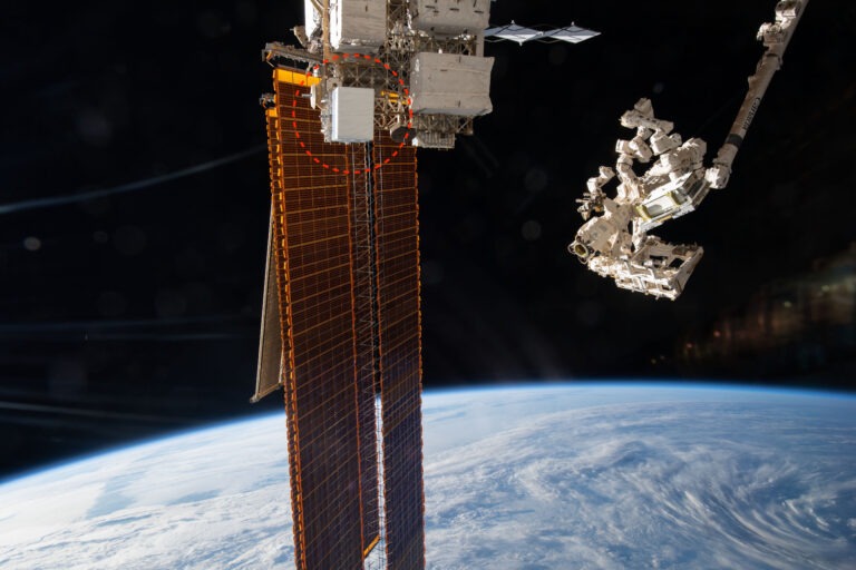
Hero Image credit NASA – NASA’s EMIT, shown in the red circle, was launched to the International Space Station in 2022 to map minerals. Its data is now advancing fields from agriculture to water science.